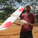
Aiming for a bird’s eye view
 A rapidly developing area of conservation and ecological research lies in the use of small radio-controlled planes and helicopters to acquire aerial imagery of landscapes. Traditional air photo surveys using light aircraft have usually been too expensive for conservation projects, as is high resolution satellite imagery, which is also hindered by the frequently cloudy skies over tropical forests.
Radio-controlled models can provide a very valuable low-cost version of aerial surveys. A Rocha International is therefore working with the Departments of Plant Sciences and Mathematics at Cambridge University, the Royal Society for the Protection of Birds and Harapan Rainforest, on a project funded by the Cambridge Conservation Initiative collaborative fund, to improve the value of the images that can be collected by such models.
In November, Dr Jeremy Lindsell (ARI’s Conservation Science Manager) worked in Indonesia, with partners, to learn how to construct and operate a plane that can be used for aerial surveys of forest canopy. This equipped him to build his own model for use on some of A Rocha’s project sites. The aim of the research is to automate the classification of the imagery acquired by the aircraft into maps that are useful for forest conservationists and managers. Jeremy says, ‘I hope the technology will prove useful for mapping and monitoring many conservation sites in ways that were not possible before.’
